

Dragon’s Tooth is a spire of Tuscarora quartzite on top of Cove Mountain, in the Jefferson National Forest near Catawba, Virginia. The tallest rock stands roughly 35 feet above the outcrop around it. The hike is one of the three that make up Virginia’s Triple Crown, along with McAfee Knob and Tinker Cliffs, and it is the one with the most scrambling.
The photographs here are from a wet, foggy day. The upper trail is bare rock, and they show how it looks when it is wet.

Photos by Adam Miller
In this guide
About Dragon’s Tooth
The trail starts at a Forest Service lot on Virginia Route 311, north of Catawba. The Forest Service lists the trail’s elevation as 1,739 feet at the start and 2,842 feet at the top. The Eastern Divide Ranger District manages it.
The blue-blazed Dragon’s Tooth Trail is the main route and climbs gradually for about the first mile. It meets the Appalachian Trail on the mountain above, and the last stretch to the Tooth follows the Appalachian Trail before a short blue-blazed spur leaves it for the rock.
The route
The Dragon’s Tooth Trail begins at the kiosk at the back of the lot. About a quarter mile in, the yellow-blazed Boy Scout Connector leaves to the left. Stay on the blue trail. It crosses a creek several times and climbs at an easy to moderate grade until it meets the white-blazed Appalachian Trail. Turn south on the Appalachian Trail, toward the Tooth.
Published distances for the round trip run from 4.2 to 4.8 miles. The Forest Service description gives 2.3 miles each way, and Roanoke Outside gives about 4.5 miles for the round trip. Published figures for the climb run from about 1,200 to about 1,600 feet, depending on the route and the device that recorded it.
On the way back you can stay on the Appalachian Trail going north and take the Boy Scout Connector to the lot. It joins the blue trail near the parking lot, and Roanoke Outside says it offers different views.

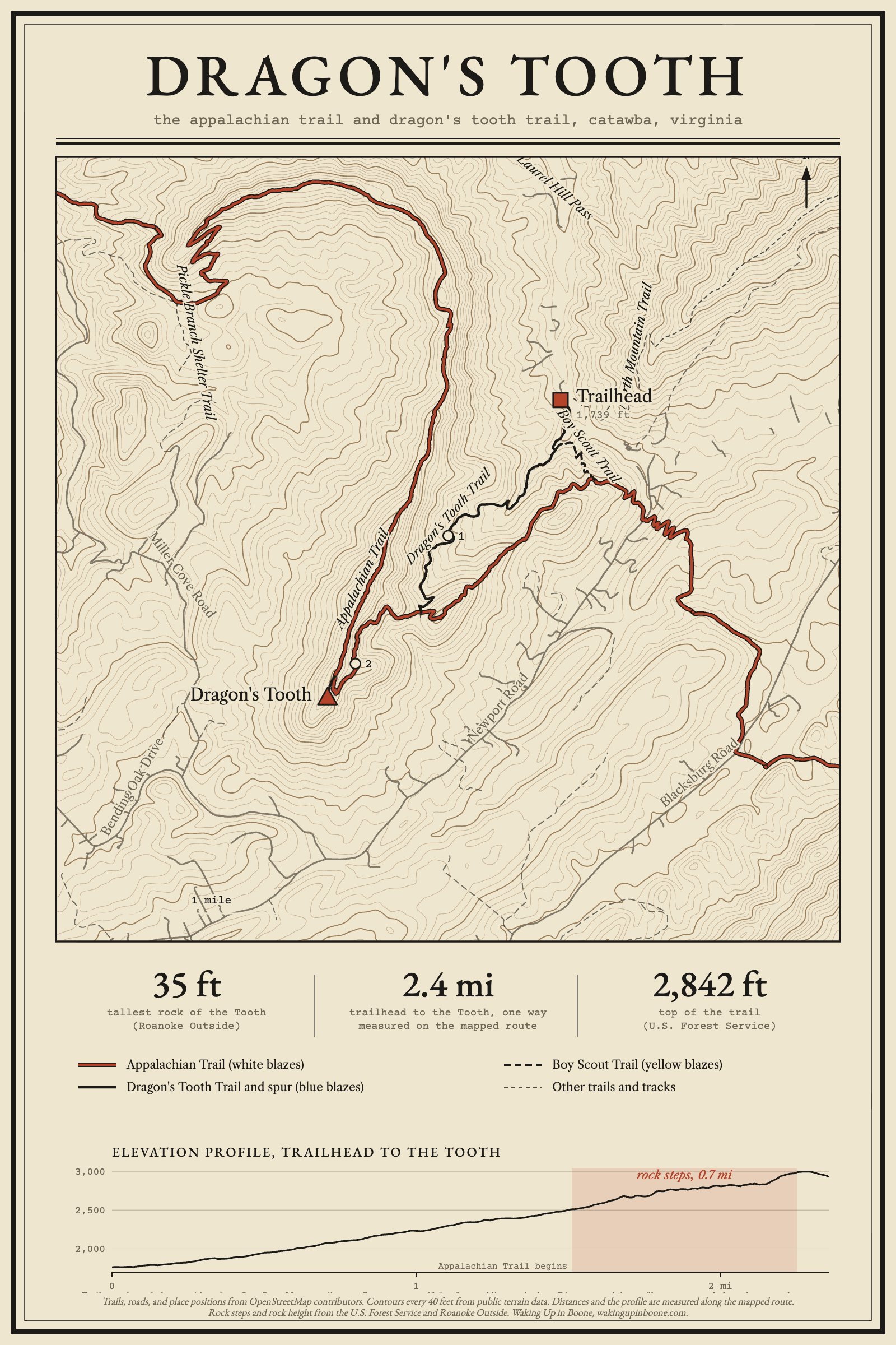
The map shows the route from the trailhead to the Tooth and the trails around it. Tap it to open the full-size file, which prints well.
The rock steps
The hard part is the 0.7 miles of the Appalachian Trail between the Dragon’s Tooth Trail junction and the spur to the Tooth. Roanoke Outside describes it as steep rock steps, and the Forest Service says to expect to use your hands and feet. In places the trail runs along a narrow ledge against a rock face, and the white blazes of the Appalachian Trail are painted on the rock itself.

Wet rock is slippery, and a heavy pack makes this stretch harder. Allow more time than the mileage suggests. The Forest Service notes that many hikers take six hours or more for the whole hike.
The Tooth
The blue-blazed spur from the Appalachian Trail to the Tooth is less than 0.3 miles and is an easier walk than the rock steps. Short side paths lead to overlooks. On a clear day the views run across the Catawba Valley and the Craig Creek Valley. In fog, as in the photographs, they are limited to the nearest rock and trees.
A crevice behind the Tooth lets hikers climb onto it. One trail guide says it is not an easy climb and suggests skipping it if you are uncomfortable with it.
The rock
The Tooth is Tuscarora quartzite, also called Tuscarora Sandstone, a layer of hard rock laid down in the Silurian period, more than 400 million years ago. The layer averages 75 to 150 feet thick and erodes more slowly than the rock above and below it, so it forms ridge tops in western Virginia. McAfee Knob, Tinker Cliffs, and Dragon’s Tooth are all high points of this layer.
When to go
The trail is open year round. Roanoke Outside calls the weekends very crowded and recommends going on a weekday, and the lot is small enough that it fills on nice weekends. The Forest Service advises allowing plenty of time and daylight. Roanoke Outside warns that groups often lose track of time and walk out in the dark, so carry a flashlight or headlamp.
Before you go
- Where: The trailhead lot is on VA 311 north of Catawba, at 37.3787, -80.1563. From I-81, take Exit 140 and drive north on Highway 311 for 11 miles toward New Castle. The lot is on the left, just past Catawba Grocery.
- Parking: The lot is limited. Do not park along Route 311, where vehicles are towed. A toilet is at the kiosk.
- Fee: None.
- Blazes: Blue for the Dragon’s Tooth Trail and the spur to the Tooth, white for the Appalachian Trail, and yellow for the Boy Scout Connector.
- Water: None is provided. Bring your own. Treat any water you take from a stream.
- Camping and fires: No camping or campfires on Dragon’s Tooth, McAfee Knob, or Tinker Cliffs. Camping and campfires are allowed only at the seven designated shelters and camping areas.
- Dogs: Dogs must be on a leash at all times. Roanoke Outside notes that one section requires lifting dogs over a wall about 6 feet high.
- Other rules: No alcohol. Day-hike groups are limited to 25 people.
- Maps: National Geographic Trails Illustrated maps 787 and 788 cover the trail.
- Contact: Eastern Divide Ranger District, 540-552-4641.
- Online guides: U.S. Forest Service | Roanoke Outside | Visit Roanoke
Details checked November 2026. Conditions and rules change, so check the Forest Service trail page before you drive.
A new story of a High Country person or place every two weeks, by email.


